Hiking trails in Bihor Mountains
Trail: Ştei – Şaua Vârtop
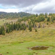
Trail: ![]() Ştei – Şaua Vârtop
Ştei – Şaua Vârtop
Area: Apuseni Natural Park
Marking: Yellow line
Length: 28 km (1 way)
Time: 7-8 hours
Difficulty: Medium
Access: by car on the E75 road (until get in Ștei city)
Points of interest: Cheia Rea valley, Țapu glade, Țapu peak, Groapa Ruginoasă (more…)
The Boghii Craggs Amphitheatre

The protected area „Pietrele Boghii” (The Boghii Craggs) accommodates one of the greatest abrupt stretches in the Bihor Mountains, and it offers the tourist eye one of the most beautiful views in these mountains. Some even consider it the most wonderful view in all the county of Bihor. Once on top of the Boghii Craggs „Amphitheatre”, you can practically feel the abyss gaping through the bluish light rays dispelled amongst the trees, and then a huge chasm lies in front of you, roughly the size of a few hundred meters. Searching for the edge of the pit, we made our way left and right, to find the perfect place to simply look on the horizon and enjoy the perfect view.
(more…)
The Betfia Pit Cave – A journey to the centre of the Earth
The Betfia Pit Cave or Huda Bradii is located on the Southwest side of the Șomleu Hill (346 m), not too far from Băile “1 Mai”, in the range of Betfia village, Sânmartin township. The cave is also referred to, by locals, as the “Betfia Crater”. The Cave has two openings: the main one, created with the help of dynamite in 1898, by T. Marta, nicknamed Brade, and a secondary one, also created with dynamite, but in 1957, by a man named I. Urs.
loading map - please wait...


The first exploration, together with a relatively complete mapping was made in 1913, by F. ARDOS (1913 and 1930), which established the cave as the mouth of a geyser. J. CSOLNOKY (1941) explains how the pit came to take form with the help of turbulence from some powerful water torrents, and then, pale ontological research conducted by E. TERZEA and T. JURCSAK (1969) establish its shallow origins. During the ‘40s, the cave was used as an ammunition warehouse by the Germans. The name “Huda Bradii” stems from those times, when the border crossed the “Cremanar” Hill and “Hudra Brady”. In 1977, L. VĂLENAŞ and N. SASU remap the entire subterranean void and establish its maximum depth at 86 m.
The main opening, a beautiful arcade, actually contains a 54 m deep, 5 8 m wide shaft. At its basis lies a cone of debris, within a large hall ( 35 x 18 x 20 m). To the Southwest, The Great Hall splits in two descending galleries: a Southern one, rich in argyle, with a 35° downward cliff and a few crossings which get clogged at about 84°(?), and another gallery, resembling an elongated hall ( 38 x 21 x 10 m), separated from the Great Hall by an inclined plane. Above the plane lies a series of blocks with a riverbed lapping through and then running out at 85 m. Generally, the pit cave is poor in stalagmite formations, it presents many cavings and houses quite a few bat colonies. At the gallery bifurcation, there has once been found a chisel dating from the Neolithic era, and within the nether areas important fossil deposits have been discovered, containing Pleistocene fauna.
Source: www.speologie.org
We’re left with the duty to respect these parts at our every step, keep them clean and pristine for generations to come, and for us as well, because in Nature, “the tourist comes to gladden his eyes, the thinker encounters a grand book where every rock is a letter, where every lake is a phrase, where every village is an accent and from whence a smoke of ancient memories emerges”. (Victor Hugo)
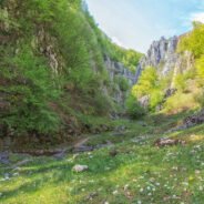
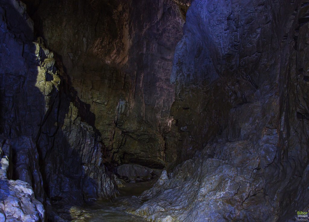
Rădeasa Cave. The cave with ceiling “chimneys”, one of a kind in Romania

Rădeasa Fortress Cave is unique in Romania, due to the chimneylike shapes scattered across its ceiling, that stretch up until they hit the surface. They usually brim over with babbling water, filling the void with its roar. Rădeasa Cave is situated within the Apuseni Natural Park, in the Northern part of the Padiș karst landscape, up in the Bihor Mountains, upstream of the Warm Someș Channel. We’re in the Apuseni Mountains, a magnificent place, where nature truly outdid itself in its own beauty: a place of meditation and reflection, a green oasis of peace and harmony.
After a short foray into the forest, we start to descend the coast and toil our way to a small valley. Once across it, we find ourselves facing the larger than life portal of the Rădeasa Cave, an ogival vault over 15 metres high. You can enter the cave from a nearby cliff, on the left water bank.
loading map - please wait...

After the first 10 metres, the cave gives way to a large hall and, by following the watercourse, we climb up some cliffs, pass under an arcade and find ourselves in another great hall, flooded by a curious light, streaming through the four “chimneys”. These chimneys crack the cave ceiling right to its surface. We can actually see them on the pathway, on our road back, shaped like shafts. The blueish light sifting through the ceiling unveils chaotic scenery, of untold beauty, with its water filled cracks and crevices. This is what makes this cave one of a kind in its country. Onwards, on a narrower, darker way, we reach a dim ray of light, springing from another ceiling chimney and we continue our adventure. Hardly noticing the ceiling disappearing, we’re suddenly out of the cave and walking through a canyon so narrow, the light barely shines upon us. We make our way down with the help of some old beams, that used to belong to a long forgotten bridge. A few gaping crevices later, we’re out of that narrowness in Rădeasa Meadow, blinded by light and warm, freshly scented air.
The entire subterranean passageway is 212 metres, adding another 47 canyon metres, at the exit.
Activites in Apuseni Natural Park Canyoning | Caving | Trekking | Mountain-bike | Tandem paragliding | Rafting – Kayaking
Accessible from the trail: ![]() The Șomesul Cald circuit trail
The Șomesul Cald circuit trail
We’re left with the duty to respect these parts at our every step, keep them clean and pristine for generations to come, and for us as well, because in Nature, “the tourist comes to gladden his eyes, the thinker encounters a grand book where every rock is a letter, where every lake is a phrase, where every village is an accent and from whence a smoke of ancient memories emerges”. (Victor Hugo)
The 19th century Traditional Home in Sălacea

loading map - please wait...

This peasant house was built in the first half of the 19th century, in Sălacea, within an area called Kis Burga. It’s probably the last monument of the terracestyle constructions, a once very popular style within the Ier Valley. Before construction began, the terraces were built by hand on the water banks. Despite creating artificial terraces, the houses were built in a slight decline, and thus a new building style was born where part of the house was sunk in the ground. An interesting characteristic of these places is that they used to build three levels of terraces, and on each level they put both homes, and cellars. Regrettably, these old homes have almost completely disappeared. However, we can rejoice with the fact that most of the cellars have managed to survive the test of time. (more…)
Roșia ‐ touristic region

loading map - please wait...

In the northern part of Beiuș Country, below Pădurea Craiului Mountains, on the inferior course of the Roșia Valley, lies Roșia, a picturesque, quiet and stupendous area, one of the largest and most beautiful townships in Bihor County This touristic region is a gateway to Pădurea Craiului Mountains, largely held as one of the most complex karst areas in Romania.
Situated upon a natural background, Roșia brings forth a number of possible activities, spectacular caverns and gorges, amazing views and landscapes. Landmarks: Cheile Albioarei (Albioara Gorges), Cheile Cuților (Cuților Gorges), Peștera Ciur‐Ponor (Ciur‐Ponor Cave) and Peștera Ciur‐Izbuc (Ciur‐Izbuc Cave) (accessible only by custodian approval and with TCE guides), Peștera Vacii (Cow’s Cave), Peștera Gruieț (Gruieț Cave), Peștera Meziad (Meziad Cave), Peștera cu Cristale din Mina Farcu (The Cristal Cave in Farcu Mine), Peștera Albă (the White Cave), Peștera Roșie (the Red Cave), Izbucul Roșiei (Roșia’s Spring), Moara de apă de la Roșia (Roșia’s Watermill).
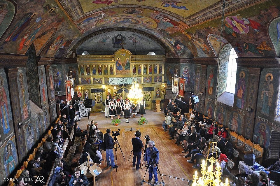
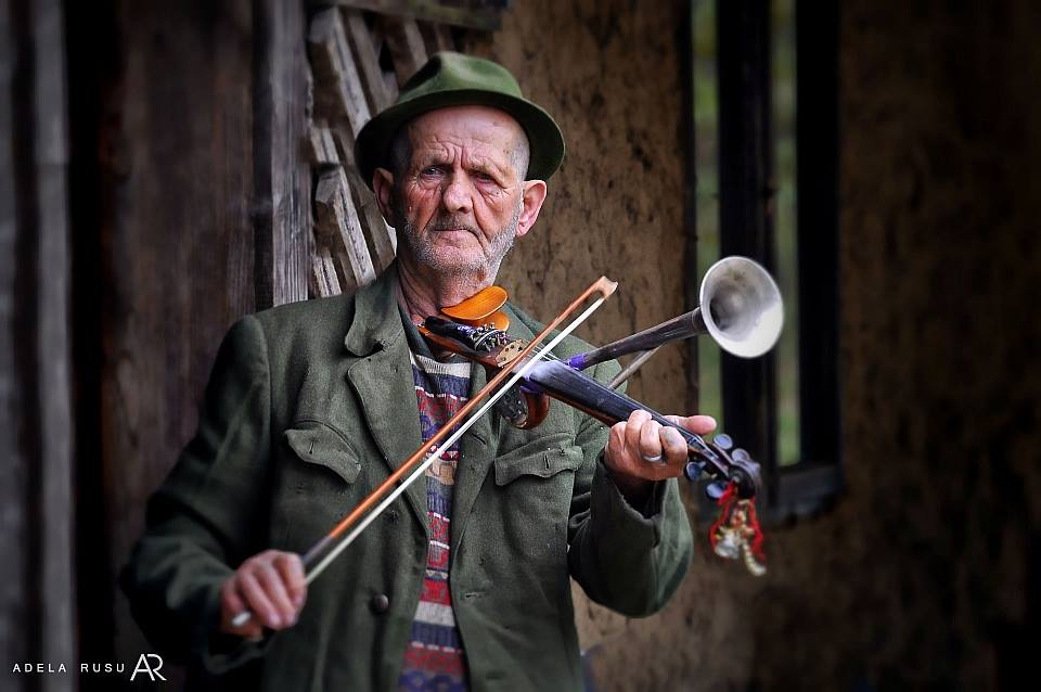
Traditions and customs: the weaving shed and horned violins collections of Codoban family, The “pricesne” festival, traditional clothing
Access: by car you travel on the E60 until Borod, then go by public highway 764 D, crossing Bratca and Damiș, until reaching Albioara Canton. Next turn left on a rocky road going up to the Runcuri plateau. Another way is by E79 until Beiuș, then DJ 764, through Remetea, until Albioara Canton, turn right towards Runcuri plateau. There are regular bus trips between Beiuș and Roșia.
Activities in Pădurea Craiului Mountains: Canyoning | Caving | Trekking
We’re left with the duty to respect these parts at our every step, keep them clean and pristine for generations to come, and for us as well, because in Nature, “the tourist comes to gladden his eyes, the thinker encounters a grand book where every rock is a letter, where every lake is a phrase, where every village is an accent and from whence a smoke of ancient memories emerges”. (Victor Hugo)
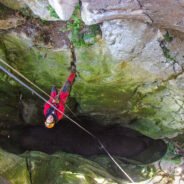
Jgheabului Gorges ‐ Wild gorges in Apuseni

We had to travel about 100 km from Oradea to Pietroasa, then it was up to the Jeep to make its way to the heart of the Apuseni Mountains. Here we encounter Jgheaburile (“Gutters”), a section of gorges downstream of Poiana Florilor (Flower Meadow), where it meets Crișul Pietros in Padiș.
loading map - please wait...

A natural phenomenon, Jgheabului Gorges are a continuance of the Yellow Gorges (Cheile Galbenei), found upon the valley with the same name. The gorges are surrounded by abrupt waterfalls and stepping stones, and the high walls and cliffs might give you the impression you’re actually captive within the walls of a fortress. They’re astounding! I wanted to come here to satisfy my adrenaline rush. So I was part of a group who were following the same thoughts, together with an authorized touristic guide. I had been to other gorges and mountains before, but the grandeur of this landscape was giving me chills. We had all been previously equipped with climbing gear, rubber boots, neopren suits and properly trained in rapel procedures. We had also been warned there were some sections of the gorges with abundant flows that might take us off balance, and one of us falling would mean all of us falling. The guide would accompany every tourist for each rapel, to keep him safe and make sure everything goes as planned.
Here I go!
The wild landscape and utter beauty of this place is breathtaking, but danger lurks at every step. You need to be an adrenaline junkie to go all the way. Crossing the waterfalls means having all that water on your head and sustaining yourself under that downpour. It literally coils your blood. It’s scary and fascinating, all at once. The effort is worth every scratch. Although soggy and frozen, we’re all extremely happy. It’s a one of a kind experience.
We’re free between the stony walls!
I return home after an unforgettable experience, and while gazing at nature’s beauty through the Jeep’s window, I remember Hillary’s quote… “It is not the mountain we conquer, but ourselves.” (Edmund Hillary)
Activites in Apuseni Natural Park Canyoning | Caving | Trekking | Mountain-bike | Tandem paragliding | Rafting – Kayaking
Accessible from the trail: ![]() Trail: Pietroasa village – Arieşeni village
Trail: Pietroasa village – Arieşeni village
We’re left with the duty to respect these parts at our every step, keep them clean and pristine for generations to come, and for us as well, because in Nature, “the tourist comes to gladden his eyes, the thinker encounters a grand book where every rock is a letter, where every lake is a phrase, where every village is an accent and from whence a smoke of ancient memories emerges”. (Victor Hugo)
Cuților Gorges
Cuților Gorges are located in the Pădurea Craiului Mountains, in the upper basin of Roșia Valley, the closest town being Roșia. Their name comes from the local term given to the rocks people used to sharpen their knives (cuți), that can be plentily found on this valley. Although not very long, the gorges are a spectacle, with their steep walls reaching heights of 60 ‐ 100 m, home to many caverns (The Singing Cave ‐ rom. Peștera care Cântă, The Cow’s Cave ‐ rom. Peștera Vacii, Bats’ Cave ‐rom. Peștera Liliecilor) and karst springs.
loading map - please wait...

The gorges consist of only about 1.3 from the total of 2.1 km, but they form a breathtakingly beautiful landscape. Somewhere along the way, the water develops into a deep, V‐shaped valley, the cliffs become steeper and steeper and, during draught season, the streams disappear, absorbed either by the waterbanks or the gravel by the rivers. The gorge section is drained by a temporary stream, following its meandered way guarded by calciferous peaks. Upon entering Ponița village, the gorges abruptly come to an end, and the chalkstone form a spectacular, steep wall, over 80 m high.
A touristic circuit has recently been developed for Cuților Gorges, but the caverns in this area are not available for tourists.
Activites in Pădurea Craiului Mountains Canyoning | Caving | Trekking | Mountain-bike | Tandem paragliding | Rafting – Kayaking
We’re left with the duty to respect these parts at our every step, keep them clean and pristine for generations to come, and for us as well, because in Nature, “the tourist comes to gladden his eyes, the thinker encounters a grand book where every rock is a letter, where every lake is a phrase, where every village is an accent and from whence a smoke of ancient memories emerges”. (Victor Hugo)
Albioara Gorges ‐ “passage” to the Pădurea Craiului Mountains

Albioara Gorges (Cheile Albioarei) can be found within the Pădurea Craiului Mountains,specifically in the upper basin of Roșia Valley (Red Valley), between Albioara Sinkhole (Ponorul Albioarei) and the village of Țarina, pertaining to Roșia region. The gorges consist of white chalkstone, are 2.6 km long and between 80 and 100 m deep.
loading map - please wait...

They’re quite spectacular with their amazing views and landscapes. DJ 764 (public highway) runs through the gorges, and it connects the cities of Beiuș and Aleșd, making it the only “passage” of entrance, from Beiuș and Roșia Depression, within the mountains and towards Vadului Depression.
Unlike other gorges in Bihor county, these are not permeated by any water courses, but they do inhabit a large number of caverns and karst springs. On both sides of the gorges you can see quite a few caves, suchs as: Urâcioșii Cave, Cow’s Cave, Horse’s Cave, Valău Cave, Cross Cave, but none of them are accessible for tourists. The Albioara Gorges are a touristic landmark not to be missed by those of you who find themselves in Roșia region.
Activites in Pădurea Craiului Mountains Canyoning | Caving | Trekking | Mountain-bike | Tandem paragliding | Rafting – Kayaking
We’re left with the duty to respect these parts at our every step, keep them clean and pristine for generations to come, and for us as well, because in Nature, “the tourist comes to gladden his eyes, the thinker encounters a grand book where every rock is a letter, where every lake is a phrase, where every village is an accent and from whence a smoke of ancient memories emerges”. (Victor Hugo)
Trail: Câmpani village – Calea Fusului (Sighiştel gorge)
Trail: ![]() Câmpani village – Calea Fusului
Câmpani village – Calea Fusului
Area: Apuseni Natural Park
Marking: blue triangle
Length: 12,5 km
Time: 6 hours
Difficulty: Medium, not recommended in winter
Access: by car on the E75 road (via road Ștei city – Câmpani village)
Points of interest: Several caves, Sighiştel gorge, Cheia Rea canyon, Dosul Muncelului vertical cave (more…)